|
|
|
|
|
|
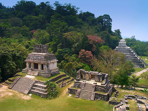 |
PalenqueNestled in the heart of a tropical rainforest climate with an average annual temperature of 26 ° C, with torrential rains during the summer, Palenque offers its visitors a stunning image of their temples and buildings explored from the S. XIX, and dating from the Classic Period (400-700 AD). Among its most important buildings are: The Palace, which is distinguished by its large tower that stands above the rest of the building; Temple of the Sun, the Cross and the Foliated Cross, which surround the Plaza del Sol and the mysterious Temple of the Inscriptions, which was discovered in 1952, with a beautifully tomb and sarcophagus tallado- trousseau funeral of King Pakal, former ruler of the city who had built this building so that, at his death, he worked as his sacred tomb.
. Lodging, restaurants, shops and markets where you can buy all kinds of crafts and savor the delicious dishes: A 6 km east of the archaeological zone and the National Park, the town of Palenque, with all services located Chiapas kitchen. Close by you will discover the waterfalls of Agua Azul and Misol-Ha, stunning natural attractions, where you can go camping and watch landscapes that formerly could only be admired by Mayan princes.
|
|
 |
TonináThe name of Tonina Tzetzal means "House of Stone" or "The place where stone sculptures rise in honor of time." Sacred space is a huge artificial mountain built on a small natural ridge of clay in the north of the valley of Ocosingo, it was lined with seven huge stone platforms on which temples and palaces were built forming a monumental maze of over 70 meters high. Some of the great Acropolis, and throughout the valley, with room areas and cultivation were distributed. Toniná presents a sculptural tradition of Maya features, however has a feature itself has magnificent stone and stucco reliefs. Tonina was a military power, found representations of prisoners in stone and stucco around the Acropolis, even central ballcourt markers are two captive, most notably a ruler of Palenque Kan called Hul.
|
|
 |
BonampakArchaeological area located in the municipality of Ocosingo, in the middle of the forest at 700 meters above sea level, has a humid temperate (22 oC annual average) climate. It is connected by means of planes from Tuxtla Gutierrez, Ocosingo and Tenosique, Tabasco.
The story of the discovery of Bonampak is coated with the same overtones of magic and tragedy that marked the excavations of Egyptian temples in the nineteenth century. The Swiss pacifist Carlos H. Frey in 1941 decides to penetrate to the Lacandon jungle, where it coexists with the Lacandon who decided to show the holy city of their ancestors. In 1946 leads the American researcher Giles C. Healy, who was the first to discover and photograph the extraordinary frescoes inside one of the temples.
|
|
 |
YaxchilánYaxchilan, notable for its large number of monuments with inscriptions of exceptional quality, is immersed in a thick blanket of tropical forest on the banks of the Usumacinta River. The development of this city happened between the years 350 to 810. Its architectural layout adapts to the characteristics of the terrain and the presence of the river, as the buildings extend from east to west on a wide limited space south by a series of elevations which serve as seats for the constructions.
Yaxchilan is the prototype of a city lost in the jungle; located on the left bank of a capricious bend of the Usumacinta, is elevated over ten meters above mean river level, occupying a central position in the Lacandon Jungle.
Its origin dates back some two thousand years, when a group of men settled forming a village that over the centuries, turned into one of the most beautiful and powerful cities in the Usumacinta Basin, and had its heyday between 550-900 DC years corresponding to the Late Classic Period.
|
|
 |
ChinkulticChinkultic in Mayan means "Well Staggered" and its chronology thanks to studies of its known pottery recovered in a section of the site. His period of bloom is located in the Classic Maya and was first mentioned by the German scholar Eduard Seler, when he made a site visit in the late nineteenth century.
|
|
 |
Tenam PuenteTenam Puente is a place that is a eponymous archaeological site. Tenam is a Nahuatl word meaning "fortification" and Puente is derived from the farm that existed at the beginning of the century in place.
The archaeological site of Tenam puente sits on a mountain overlooking the Comiteca, very plain that extends to the Lagunas de Montebello; there are across 2 km2 to meny kind of constructions civic, religious and housing type, raised on large platforms with huge walls. These walls are arranged into five different levels, thus achieving the formation of open and closed spaces on the main buildings, some of which appear as characteristic element ramps stone buttresses are distributed way.
|
|
|
|
|
|


